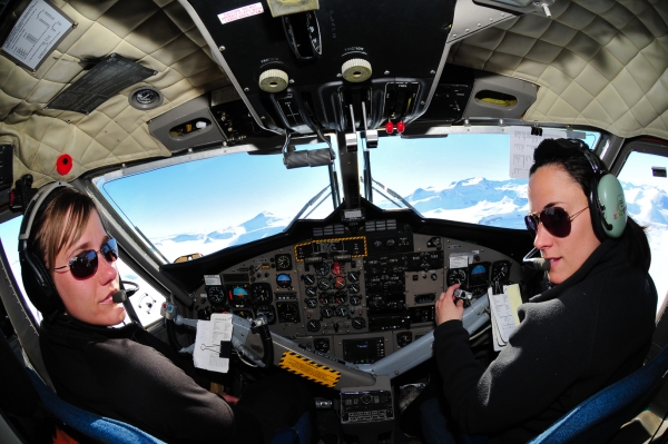
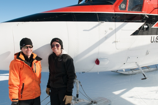
Lexi Crocker does not fit the mold of a traditional Antarctic Twin Otter captain. She’s 26, blond, petite—and at this moment rather short-tempered, as it’s hard to tell the difference between the low fog layer and the infinite expanse of the East Antarctic Ice Sheet sitting just below it.
Lexi is following a GPS bearing towards “Hatcher Bluffs” (86°20′S 125°36′W)—one of the world’s most southerly outcrops of rock (the majority of the Antarctic continent is buried under about two miles of ice). The Transantarctic Mountains should be somewhere off to our left, but we can’t see them. Perhaps they’re still over the horizon, or maybe the fog layer is obscuring it. Or maybe the GPS bearing is incorrect—who knows who input these obscure Antarctic locations into the flight database.
Erika Di Lena, 27, scans the polar horizon from the Otter’s right seat. Neither of the crew show any concern. After all, even if we’re off course it’s probably only by a little bit. But down here, a slight course error might cause significant fuel management issues—as each leg of our journey will demand just over half a tank of AN-8. We joke about the instruments being incorrect, and how hard it must have been in the days prior to GPS. “We carry a sextant” says Erika. She points vaguely to an area near her feet where it is stored. “We’re supposed to be proficient at using it—in case the GPS dies.”
Thankfully, within minutes we notice the tops of a few peaks of the Central Transantarctic Range on the distant left horizon. We’re right on course and only needed to spot a few comforting landmarks to confirm it.
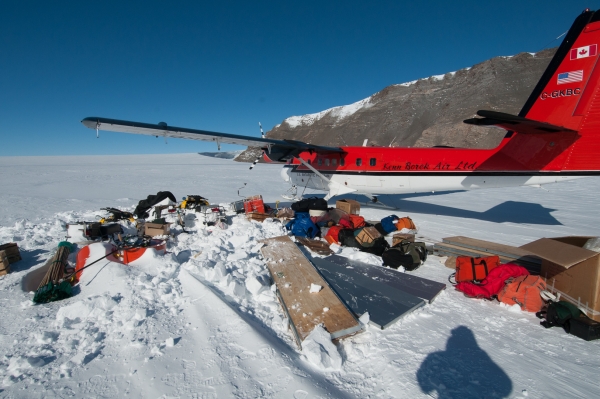
Hatcher Bluffs is our destination, and in the back of the Otter are four scientists, a bunch of emergency and field equipment, and me—their hired “Antarctic Field Mountaineer.” My job is essentially to be a deep-field risk management consultant. The service I provide these scientists is based on an amalgamation of my academic field geology background, a 10-year mountain and ski guiding career, and a few seasons of deep-field logistics and safety planning for the U.S. Antarctic Program. My perpetual curiosity about oddball aviation, and the availability of an extra headset, has led me to crawl over miscellaneous cargo to the seat directly aft of the Otter’s forward bulkhead. There, I spend both legs of our 2.25 hour “commute” talking shop with Lexi and Erika, and getting to know just what brought them down here to the ice.
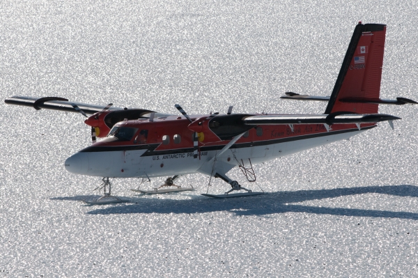
First, some background on Antarctic aviation for the United States Antarctic Program (USAP). Kenn Borek Aviation holds the exclusive contract to operate deep-field fixed wing services to the Antarctic Program with their fleet of de Havilland DHC-6 Twin Otters and Basler BT-67s (turbine-modified DC-3s).
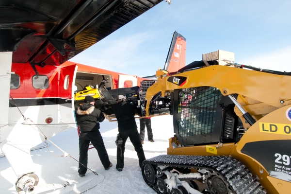
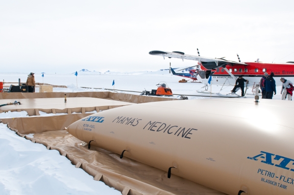
To get heavy cargo and personnel from New Zealand onto the continent, USAP relies on the support of one U.S. Air Force C-17 cargo jet from Joint Base Lewis-McChord in Washington. The C-17 needs a long, exquisitely manicured ice runway to operate from, so the gigantic cargo plane isn’t appropriate for any of the other groomed snow strips (or off-runway locations) in Antarctica. The New York Air National Guard operates a small fleet of LC-130 ski-equipped Hercules cargo planes for the heavy lifting between McMurdo, “Pole,” and other higher population science camps like Siple Dome, WAIS divide, and CTAM. But that leaves a whole continent of ice, sastrugi, gravel, and other surfaces that can only be served by small, more nimble off-runway fixed wing service.
And that’s where the Kenn Borek aircraft come in. Every October, several Otters and Baslers are ferried by their crews from the Kenn Borek Air base of operations in Calgary, all the way down the west coast of South America, to Rothera—a science station operated by the British Antarctic Survey—where wheels are swapped out for skis. After one more refueling stop on the western half of Antarctica, the Kenn Borek crews eventually land at the “skiway” in McMurdo, where they spend just under three months moving cargo, scientists, staff, and fuel to the most difficult to reach locations in Antarctica.
“What the … I still don’t see anything! Are we sure these points are input correctly?” Lexi says out of only slight concern.
Our GPS says Hatcher Bluffs should be dead ahead, about 40 miles away, but all we see is white ice sheet beneath us, cloaked with a broken white low cloud layer, all in front of a horizon obscured with white stratus. Erika checks the GPS, and rechecks it. I peer at my own personal GPS, and check the latitude and longitude on our U.S. Geological Survey topographic map. Yep, all the numbers seem correct … With nothing to do but watch the “Distance to Destination” shrink steadily, we continue the career conversation.
Lexi has been a commercial pilot since the end of her teens. As of January 2011, she’d logged more than 5,000 hours—much of it as captain. She started out at Courtesy Air, in North Saskatchewan, flying the Navajo and King Air. She lucked out starting there—she was looking to build time without instructing, and the company just happened to want a female crew member who lived near Buffalo.
With around 2,700 hours and four years of commercial experience, Erika doesn’t hide the fact that she’s in this job to build some time, go captain, and maybe move into airlines in the not too distant future. After 650 hours, much of which was part-time instructing, Erika moved into the King Air and flew right seat for medivacs, but found it hard to log much time with such an unsteady schedule.
There’s no way to talk to these two without the gender issue coming up. Aviation is so typically male-dominated, as is Antarctic fieldwork in general. I ask if there’s anything “easier” about being a female pilot in Antarctica or northern Canada.
“As girls, we get lots of compliments” says Lexi. “We get our pictures taken everywhere.”
I have to set my camera down so I can write this in my notebook.
But the reality can be frustrating. Lexi continues, “I was a 20-year-old captain, with a 40-year-old FO, and passengers would always defer to him.” Lexi flew a number of medical missions for Courtesy Air, and noted the prevalence of gender stereotypes. “On a medivac, I’d jump out of the cockpit with my white flight uniform on, and some person on the ground would always come up to me and ask, ‘how’s the patient doing?’”
Then Erika cuts in: “Yeah, people assume you are a flight nurse because you are female….” She continues to elaborate on the general public’s inability to comprehend. “Yeah, a lot of times we meet people on the ground and they ask, ‘So, what do you do for Kenn Borek?’ and we say, ‘We fly Twin Otters’ and they say, ‘Yeah sure, but what do you actually do for Kenn Borek?’ And we have to say, ‘Well, we FLY the twin Otters!!!’”
After an awkward “I hope we’re going the right way” pause, Lexi shouts “There! I see something, off to the left!” Within seconds Erika and I spot it too. Shades of brown and grey bedrock flanked by 10-mile-long ribbons of moraine, all rolling over the horizon toward us at 110 knots.
“ETA 12 minutes,” Lexi informs us. I check to see that I’ve got something resembling a seatbelt within reach, and our conversation takes a pause for a bit.
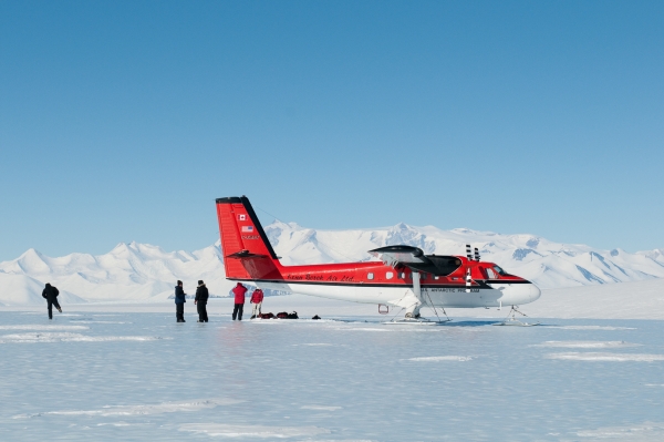
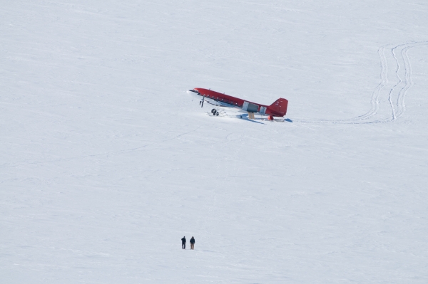
In a few minutes Lexi and Erika are adding flaps, adjusting pitch, and turning onto final toward a patch of blue-grey ice adjacent to Hatcher Bluffs. We hit the ice with a few bumps and skips—the ice is rough and sun cupped—and there’s a bit of a nasty cross wind. Lexi, like most other KBA captains I’ve worked with, taxis us as close as she dares get to the edge of the glacial moraine we seek to investigate. She stops about a quarter mile from the rocks. “There’s a lot of little sharp rocks sitting on the ice that we couldn’t see from the air—it tears the bases of the skis apart, makes them steer bad, and they’re expensive to fix.”
The walk is short, but brisk. The four geologists and I spend a few hours hunting around the moraine, taking samples of rocks that have been dragged extremely long distances (hundreds and thousands of kilometers) by the polar ice sheet. Lexi and Erika hang out in the Otter, where it’s bound to be warmer. A constant polar katabatic breeze blows here. At an altitude of 8,000 feet, and an ambient air temp of -30° to -35° F, it’s not exactly warm.
Eventually, we see the two women climb out of the aircraft and walk over to us. They join us for a while, learning from Dr. John Goodge—the principle investigator—what the project is all about. Lexi even delivers a small pile of prospective rock samples to John.
Before long, Lexi and Erika inform us it’s time to go. This crew operates on a fairly standard-length duty day, which is usually around 12 hours. Given the six hours of round trip flight time, and the refueling, we were only meant to have about four hours on the ground here anyway. And that’s about wrapped up. Dr. Goodge and the others drag a few hundred pounds of rock specimens over to the Otter, we load up, and are soon airborne—basking in the warmth of the Otter’s interior.
During our return journey to the groomed skiway at the Central Transantarctica Mountains camp (CTAM), Lexi and Erika expound on some of the idiosyncrasies of their past jobs.
I ask them why they prefer the Otter to the Basler. “Less cargo weight” replies Lexi. “It’s easier to load.”
Erika clarifies. “The Basler is a tail dragger. It sucks pushing hundreds of pounds of weight up the back of that airplane.”
In Antarctica, there is no end to the weirdness of cargo flown. But both Lexi and Erika appreciate the human elements of flying here.
I ask them about the weirdest piece of cargo either of them has ever flown. Erika recounts the tale of transporting 20 dead and frozen caribou back to a village in Northern Canada. “Once the cabin heats up, the blood goes everywhere …”
Lexi echoed that with a tale of transporting incompatible cargo: a dead body and a team of sled dogs. Upon smelling the scent of a rapidly warming dead human, the dogs became listless and agitated. “That’s something I learned not to do again,” she tells me.
After several hours of flying over the ice sheet, the first section of mountains on the horizon are those of the Dominion Range—just south of the Beardmore glacier. The Beardmore was the glacier that Earnest Shackleton, on his unsuccessful 1907 attempt, and R.F. Scott, on his tragic 1911/1912 disaster, used to ascend from the relatively low Ross Ice Shelf up to the 8,000-9,000 foot Polar Plateau. From our airborne view, it seems a difficult challenge indeed.
Lexi and Erika continue discussing their careers. Lexi wants to get a “normal” flying job out of Calgary—perhaps flying King Airs on medivacs. Erika sees an airline career in her future. The flying in Antarctica is hard work by almost any aviation standard, and this crew, like every other, works six back-to-back 12-hour days per week. Each day is full of flight planning, briefings, fueling, loading, unloading, and flying to some of the most remote places on planet Earth. It’s not hard to understand why only a rare few of the pilot breed would prefer working on this continent for more than, say, 10 years.
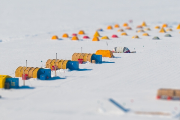
Our conversation in interrupted when we see the Queen Alexandria range and Skywalk peak off to our right. CTAM is dead ahead at 5,000 feet, on the upper end of the Lennox King glacier. Erika is PIC, and takes us through the standard descent and approach routine. Before long, CTAM’s immaculate 10,000-foot groomed skiway (necessary for fully loaded LC-130 resupply flights) sits stretched out directly in front of us. And, less than 200 feet from the taxi apron, is our 100-foot long galley tent, where dinner is about to be served.
All photographs ©2013 TaylorAlpine.com
Contributing writer Dylan Taylor is a UIAGM internationally licensed mountain guide based in Chamonix, France. He’s a reformed geologist, a paragliding pilot, an Antarctic field mountaineer, and a freelance writer and photographer. He’s also Aidan’s friend and climbing partner.
No comments yet.